

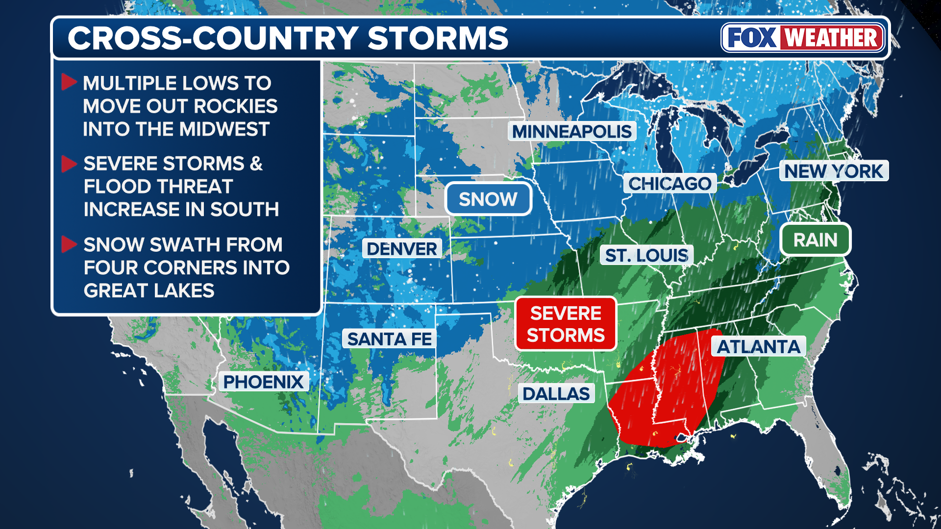
Dual cross-country storms are expected to bring heavy snow to areas of the Southern Plains and Midwest through the weekend. Winter Weather Alerts area already issued in Michigan and Wisconsin, as some areas are expected to see over a foot of snow.
As a pair of cross-country storms develop and continue to push from the Four Corners into the Midwest, rounds of moderate to heavy snow are being dropped across the region. The first storm has already brought over a foot of fresh powder to areas of Colorado, and is now moving onto the Great Lakes. The second system will bring even more snow to the Four Corners and the Great Lakes over the weekend.
(FOX Weather)
SEVERE STORM THREAT EYES MILLIONS ACROSS SOUTHEAST, DEEP SOUTH FROM POWERFUL CROSS-COUNTRY STORM
South: Four Corners and Southern Plains
Winter Weather Alerts continue to be in place for higher elevations of the Four Corner States, such as Colorado, Utah, Arizona and New Mexico. Another round of snow will arrive to the area into Friday as another low moves through, eventually pushing into the Plains and Great Lakes by Saturday.
Snow totals across the Four Corners will be around 1–3 inches from Colorado into Arizona, while higher terrain will likely see 5–8 inches of snow. The heaviest snow totals of 8–12 inches will be possible for the highest elevations of the southern Rockies, where cold air will remain cold through Saturday.
30+ STATES TARGETED BY BACK-TO-BACK CROSS-COUNTRY STORMS
According to the FOX Forecast Center, since the first cross-country system pushed a bit further eastward, areas like Salt Lake City, which has yet to receive an inch of snow this season, have missed out again. The Utah capital remains at nearly a two-feet snow deficit as of early January with no major snow in the forecast.

Four Corners snow forecast through Saturday morning
(FOX Weather / FOX Weather)
The final round will shift east out of the region and into the Plains by Saturday morning, where portions of the Oklahoma and Texas Panhandles and northwestern Kansas could see a widespread of 1-3 inches of snow.
North: Midwest and Great Lakes
Overnight on Thursday, mostly rain began moving through the Upper Midwest and Great Lakes as the first cross-country storm remains on the warmer side.
Cooler air will be pulled in on the back-edge of this first system, which will allow for areas across the Upper Penninsula of Michigan, stretching down to the Green Bay area, to flip over to a wet snow.
Winter Weather Advisories are now in place across northern Wisconsin and Michigan, including Marquette, Michigan.
PAIR OF CROSS-COUNTRY STORMS TO BRING RAIN, SNOW AND SEVERE WEATHER THREAT TO MILLIONS BY LATE WEEK
From Friday into Saturday, the second cross-country system will move into the Plains, and cooler air will surge behind the first system, creating favorable chances for snow from the Midwest into the Great Lakes over the weekend. The coldest air will continue to be confined to the Upper Midwest and northern Great Lakes.
According to the FOX Forecast Center, the latest forecasts will keep this second low a bit further east, with a weaker area of low pressure moving in behind it, limiting some snowfall across the Upper Midwest and Great Lakes into Saturday morning.
Snow totals will generally be on the lighter side across the Midwest, with 1-3 inches likely. The arrival of more cold air will cause snow totals to increase closer to the Great Lakes.
3-5 inches of snow is likely across the Upper Penninusla of Michigan, with a strip of 5-8 inches of snow expected to fall between Green Bay, Wisconsin and Alpena, Michigan through Sunday.
Gusty winds will develop across Michigan’s Upper Peninsula, leading to blowing snow and localized whiteout conditions Saturday night into early Sunday.

(FOX Weather)
HOW TO WATCH FOX WEATHER
While some uncertainty remains in the forecast, stick with FOX Weather as the team continues to fine-tune data and update snowfall projections as the storms move through.
#crosscounty #storms #bring #snow #Corners #Great #Lakes