
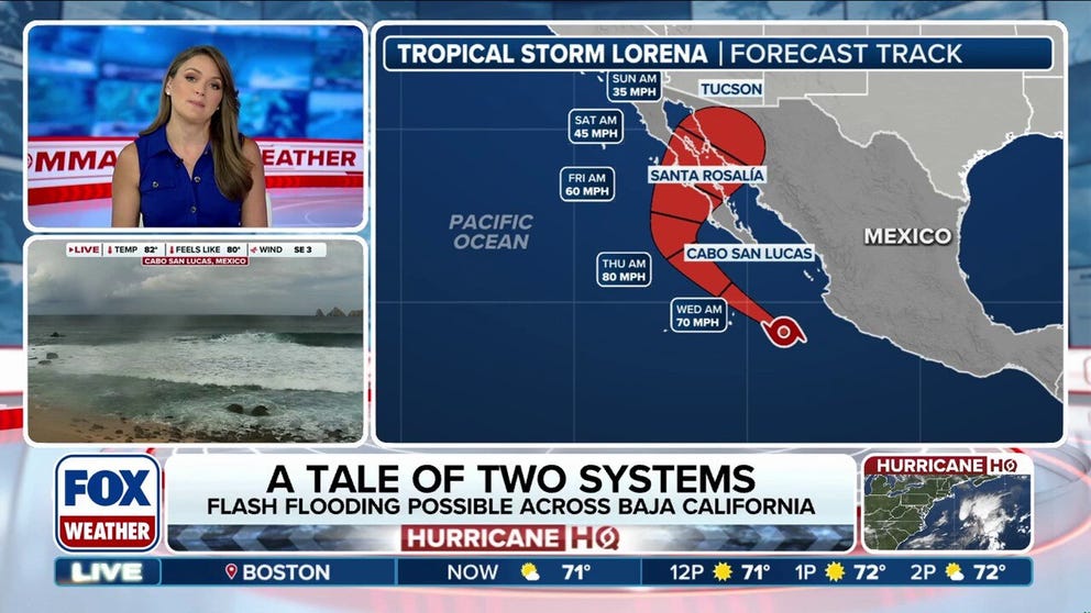
Tropical Storm Lorena formed Tuesday morning in the Eastern Pacific Ocean in the waters off the southwestern coast of Mexico. The current forecast is for Lorena to race to the northwest before slowing down and turning northeast towards Baja California by the end of the week. The track would bring increased rain chances for part of the U.S. as moisture would funnel northeastward towards Mexico and the Southwest.
Tropical Storm Lorena formed in the Eastern Pacific Ocean on Tuesday morning off the southwest coast of Mexico, and the National Hurricane Center (NHC) says Tropical Storm Watches could be issued later Tuesday for portions of the Baja California Peninsula.
According to the FOX Forecast Center, some of the tropical moisture from Lorena could enhance the seasonal monsoon weather pattern across the Southwest U.S., with heavy rain beginning late Thursday or early Friday.
Tropical Storm Lorena is currently about 240 miles west of Manzanillo, Mexico.
The NHC said that Tropical Depression Twelve-E strengthened into Tropical Storm Lorena Tuesday morning when sustained winds reached 45 mph, officially designating it as a tropical storm.
WHAT’S THE DIFFERENCE BETWEEN A TROPICAL DEPRESSION, TROPICAL STORM AND HURRICANE?

(FOX Weather)
A tropical storm is a tropical cyclone that has maximum sustained winds between 39 and 73 mph – an upgrade from a tropical depression.
The current forecast track calls for Tropical Storm Lorena to move northwestward, parallel to the Mexican coast, before potentially moving over part of Mexico’s Baja California Peninsula sometime Friday.
According to the FOX Forecast Center, heavy rain is expected to start impacting Baja California by Wednesday, with 4-8 inches of rain possible.
NOAA has indicated that Hurricane Hunters may investigate the system Wednesday afternoon.

(FOX Weather)
According to the FOX Forecast Center, abundant atmospheric moisture from Lorena will surge into the Southwest U.S. from Thursday into the weekend.
While the heaviest rain is expected across Mexico, parts of Arizona and New Mexico could receive a widespread 1-2 inches of rain, with locally higher amounts possible.
This is a somewhat similar pattern to the heavy rain that fell across parts of Southern California and Nevada last week, which was somewhat enhanced by the moisture from the remnants of Tropical Storm Juliette.
Phoenix also saw a massive dust storm last week, known as a haboob, which is caused by the monsoon weather pattern.
SAN DIEGO SEES RARE AUGUST RAIN AS REMNANTS OF TROPICAL STORM JULIETTE FUNNEL MOISTURE INTO WEST, SOUTHWEST
The Eastern Pacific Basin has already had an active start to the season, producing 10 named storms so far, five of them hurricanes, including three that reached Category 3 strength or higher.
BRYAN NORCROSS: COMPUTER FORECASTS SHOW THE ATLANTIC DISTURBANCE DEVELOPING THIS WEEK
Elsewhere in the Pacific Basin, Hurricane Kiko, which also formed Wednesday morning, is moving into the Central Pacific Ocean in the general direction of Hawaii.
The Eastern Pacific hurricane season runs from May 15 to Nov. 30.
#Tropical #Storm #Lorena #forms #Pacific #impact #Southwest #Baja #California

