FOX Weather meteorologist Steve Bender breaks down who could see rain and severe storms on Wednesday.
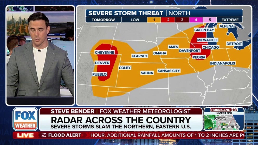
CHICAGO – A clash of air masses on Wednesday will result in the threat of severe storms from Milwaukee and Chicago westward to Denver and the eastern Rockies.
The Storm Prediction Center has placed large parts of Illinois, Wisconsin, and Colorado under a “slight” risk of severe storms – a Level 2 out of 5 on its severe storm scale.
Cities such as Milwaukee, Chicago, Green Bay, Peoria and Davenport are all included in the threat in the eastern zone, while Denver and Cheyenne are included in the western risk zone.
The FOX Forecast Center says the greatest potential for severe storms will develop Wednesday afternoon and evening, as factors such as daytime heating and instability reach their peak.
The stronger cells could produce hail, damaging wind, and even tornadoes, but the biggest threat will be gusty winds as the storms generally move from west to east.
The threat of severe weather is expected to taper off between sunset and the overnight hours as the frontal boundary slowly moves through the region.

(FOX Weather)
WHAT’S BEHIND ALL THE RECENT EXTREME FLOODING?
In addition to the severe weather threat, dew points and precipitable water values are expected to be high, meaning any thunderstorm that develops will have the potential to drop 1-2 inches of rain in a short period, leading to a flash flooding threat.
Communities around Davenport, Iowa, and Chicago have already experienced significant flooding, with areas recently placed under Flash Flood Warnings and Flash Flood Emergencies.
Just 6 inches of moving water can knock an adult off their feet, while a foot of floodwater can cause a vehicle to stall and float away.
According to NOAA historical data, an average of 127 people die from flooding each year, with nearly half of those fatalities involving vehicles.
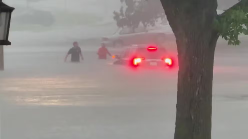
Two men had to wade through feet of water to escape flooding in Davenport, Iowa Friday.
KNOW YOUR FLOOD TERMINOLOGY: WHAT FLOOD WATCHES, WARNINGS, AND EMERGENCIES REALLY MEAN
In addition to providing some drought relief, the wet weather is expected to help clear the air of wildfire smoke that has lingered over the region.
Air quality alerts were in effect before the arrival of the wet weather, as wildfires from Canada and daily pollution combined to produce unhealthy levels of ozone.
Authorities in the Windy City declared an “Air Pollution Action Day” on Tuesday as particle and ozone levels were expected to reach the unhealthy range.
Newsportual Weather Service encouraged children and sensitive adults to limit outdoor activities and spend time in a well-ventilated setting.
Once the front moves through, it should bring more pleasant weather, with highs expected to reach only the 70s on Friday and 80s on Saturday before more wet weather moves in over the weekend and into next week.
#Severe #storms #Wednesday #front #stretched #Chicago #Denver