FOX Weather Hurricane Specialist Bryan Norcross tackled hurricane season questions in a recent livestream, addressing Saharan dust, hurricane formation zones and the growing role of AI in forecasting.
During a livestream broadcast, FOX Weather Hurricane Specialist Bryan Norcross fielded viewer questions about the 2025 hurricane season, touching on everything from Saharan dust to the role artificial intelligence is playing in forecasting.
Fortunately, the Atlantic basin remains quiet with no signs of activity brewing, but the central and eastern Pacific are rather active, with several named storms to track.
FOX Weather viewers questioned whether the Saharan air layer is playing a role in the reduction of activity across the Atlantic, Caribbean, and Gulf.
Norcross noted that while satellite information shows a decline in the SAL, caution is needed when interpreting the data.
“It doesn’t look like any kind of record-low amount of dust or anything,” Norcross stated, referencing recent imagery.
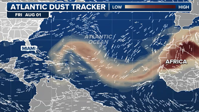
Atlantic basin dust tracker on 8/1/2025
(FOX Weather)
HURRICANE HUNTERS FLY INTO WORLD’S WORST WEATHER. SEE WHICH STORM WAS THE BUMPIEST
Asked whether parts of Florida have become more hurricane-prone during the past decade, Norcross said such clustering tends to happen in cycles. He noted similar hurricane clusters have occurred historically, including a notable period in the mid-20th century, and said the current trend may simply be another phase.
“I would guess that it’s just a phase,” he said. “The west coast of Florida has always had hurricanes.”
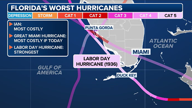
Florida’s worst hurricanes
(FOX Weather)
Another viewer asked whether the peak of hurricane season has shifted later in the year, with recent seasons appearing to be backloaded.
Norcross acknowledged recent trends, citing patterns connected with the status of the El Niño–Southern Oscillation, which have helped push storm development deeper into the fall.
The FOX Weather hurricane expert noted that for Florida specifically, September and October are often peak landfall months, so backloaded seasons have not changed vulnerabilities for the Sunshine State.
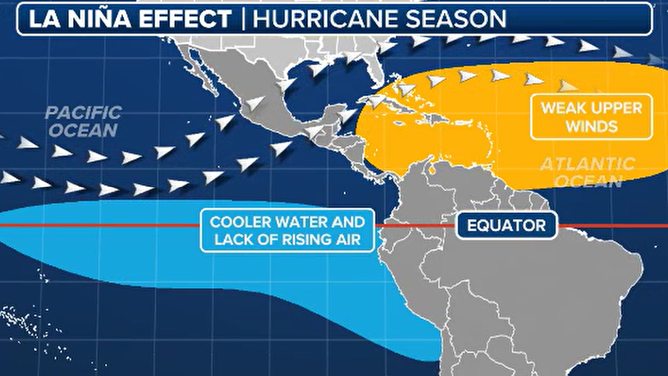
La Nina hurricane season impacts
(FOX Weather)
2025 ATLANTIC HURRICANE SEASON GUIDE
The conversation also touched on artificial intelligence and how it might enhance long-range forecasting.
Norcross pointed out that AI models are developing quickly and have the potential to dramatically improve medium- to long-term forecasts, but he cautioned that this year marks the first season these tools are being tested in real time.
“This is our first season to actually see all this in action,” said Norcross.
Norcross also explained the mechanics behind rapid intensification and the problems it sometimes causes for forecasters.
While forecasting confidence in the area of intensity has improved, understanding the exact internal processes remains a challenge – particularly without detailed observations inside a cyclone’s core.
Looking ahead, Norcross said the Madden-Julian Oscillation (MJO), a pulse of atmospheric energy, may enhance Atlantic storm activity later in August. However, he noted that similar setups have previously failed to produce cyclones, leaving some uncertainty as to when the next named series of storms will develop.
As for conditions over the Pacific Ocean, Norcross said systems currently southwest and southeast of Hawaii are tracking well south of the islands and don’t pose a significant threat.

(FOX Weather)
#Saharan #dust #forecasting #dominate #topics #hurricane #season