

Millions of people in the southern Plains and along the Gulf Coast are facing a multiday flash flood and severe weather threat this week due to an Omega block weather pattern. FOX Weather Meteorologists Britta Merwin and Ari Sarsalari break down the latest forecast on Monday, May 5, 2025.
Millions of people in the southern Plains and along the Gulf Coast will be keeping a close eye on the forecast this week as the region faces a major flash flood threat, as well as a severe weather risk, fueled by a stubborn “Omega block” weather pattern.
An Omega block is named after the Greek letter Ω and disrupts the usual zonal flow of weather systems.
The FOX Forecast Center said a large area of low pressure is expected to enter the region on Monday. That will pull in moisture from the Gulf and push it northward into the southern Plains before moving into the Gulf Coast region as the week continues.
HOW TO WATCH FOX WEATHER
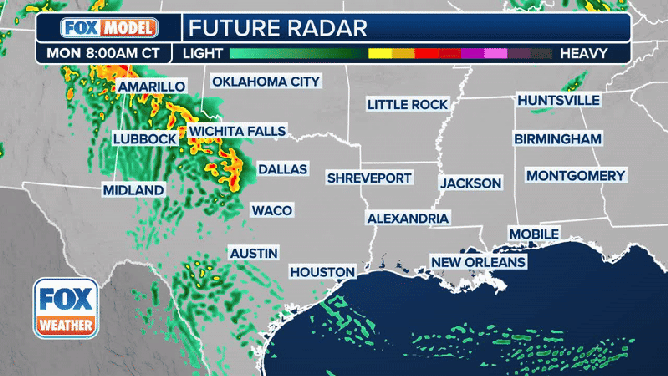
The exclusive FOX Weather Futuretrack shows heavy rain and thunderstorms moving into the southern Plains and along the Gulf Coast this week.
(FOX Weather)
The area of low pressure is situated over the Desert Southwest and will drift off to the east on Monday, providing a favorable setup for heavy rain from the New Mexico border into areas of the Texas Panhandle.

FILE VIDEO – FOX Weather Meteorologist Bob Van Dillen bravely rescued a woman who had driven into floodwaters in Atlanta. Carrying her on his back through chest-deep water, watch as Van Dillen, a towering 6-foot, 1-inch man, demonstrated incredible strength and courage during Hurricane Helene coverage.
That region is expected to experience relentless rain and thunderstorms, particularly in the afternoon and evening.
Rainfall totals of 2-4 inches are possible over a broad area, with some locally higher amounts possible.
DOWNLOAD THE FREE FOX WEATHER APP

(FOX Weather)
Tuesday is expected to see more flooding impacts, prompting NOAA’s Weather Prediction Center to place parts of Texas, Oklahoma, Arkansas, Louisiana and Mississippi at a Level 3 out of 4 risk of flash flooding.
However, there remains some uncertainty about where the heaviest rain will fall. Some computer forecast models show a faster progression with the system, shifting the higher rainfall totals to the east. Other models show the heaviest rain remaining over East Texas and northern Louisiana.
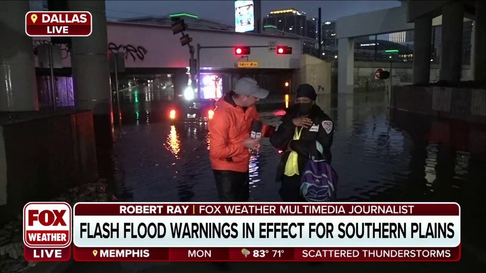
FILE VIDEO – FOX Weather’s Robert Ray helped rescue a woman from her submerged car in Dallas. She said, “I thought I was going to die.”
By Wednesday, the flash flood threat will shift to the central Gulf Coast, where a Level 2 out of 4 threat exists. The heavy rain could continue along the Gulf Coast and into parts of the Southeast by Thursday, possibly into the start of the weekend.
KNOW YOUR FLOOD TERMINOLOGY: WHAT FLOOD WATCHES, WARNINGS AND EMERGENCIES REALLY MEAN

(FOX Weather)
The highest rainfall totals are expected to be found from East Texas through Alabama.
However, portions of Texas, Louisiana and Mississippi could see well over 5 inches of rain, with some spots potentially picking up 8 inches or more.
HOW HEAVY IS IT REALLY GOING TO RAIN?
Severe weather threat ramps up this week

(FOX Weather)
The same area of low pressure responsible for the flood threat is also expected to fuel a severe weather threat across the region.
The FOX Forecast Center said that cloud cover and increasing moisture will complicate how things unfold on Monday. This is because, as the upper-level low-pressure system approaches, a dryline – a boundary separating a humid air mass from a much drier air mass – will set up. By early Monday evening, however, the atmosphere will become more favorable for storms to develop.
Very large hail, damaging wind gusts and tornadoes will all be possible within thunderstorms that develop on Monday. The cities with the highest tornado threat include Midland and Odessa in Texas.

FILE VIDEO – A massive wedge tornado was caught on video spinning across the Nebraska landscape near the communities of Bingham and Ashby on Sunday, April 27, 2025.
On Monday, more than 52 million people across the U.S. will be at risk of severe weather. However, NOAA’s Storm Prediction Center placed just under a half-million people in West Texas and southeastern New Mexico under a Level 3 risk of severe weather on its 5-point severe thunderstorm risk scale.
On Tuesday, more than 38 million people in the country will face a severe weather threat, but just over 17 million in Texas and Louisiana have been placed in a Level 2 out of 5 threat.
Tuesday’s threat includes cities such as Dallas, Houston and Waco in Texas.
#Multiday #severe #weather #flooding #threats #eye #southern #Plains #Gulf #Coast