Millions of people in the Northeast are at risk of seeing some severe thunderstorms on Tuesday afternoon and evening. FOX Weather Meteorologists Bob Van Dillen and Marissa Torres break down the forecast on June 10, 2025.
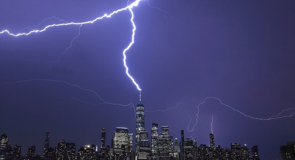
NEW YORK – Millions of people living in the Plains and along the East Coast are again at risk of severe weather and flooding on Tuesday, one day after a possible tornado left significant damage in western New York.
HOW TO WATCH FOX WEATHER
-

This image comes from drone video that captured the aftermath of a tornado-warned storm in Cattaraugus County, New York, on Monday, June 9, 2025.
(@weather_buffalo via Storyful) -

This image comes from drone video that captured the aftermath of a tornado-warned storm in Cattaraugus County, New York, on Monday, June 9, 2025.
(@weather_buffalo via Storyful) -

This image comes from drone video that captured the aftermath of a tornado-warned storm in Cattaraugus County, New York, on Monday, June 9, 2025.
(@weather_buffalo via Storyful) -

This image comes from drone video that captured the aftermath of a tornado-warned storm in Cattaraugus County, New York, on Monday, June 9, 2025.
(@weather_buffalo via Storyful) -

This image comes from drone video that captured the aftermath of a tornado-warned storm in Cattaraugus County, New York, on Monday, June 9, 2025.
(@weather_buffalo via Storyful) -

This image comes from drone video that captured the aftermath of a tornado-warned storm in Cattaraugus County, New York, on Monday, June 9, 2025.
(@weather_buffalo via Storyful) -

This image comes from drone video that captured the aftermath of a tornado-warned storm in Cattaraugus County, New York, on Monday, June 9, 2025.
(@weather_buffalo via Storyful) -
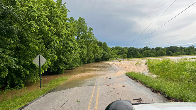
This image shows flooding in Washington County, Arkansas, on Saturday, June 7, 2025.
(Washington County Sheriff’s Office/Facebook) -

This image shows a tree that was brought down in Washington County, Arkansas, on Saturday, June 7, 2025.
(Washington County Sheriff’s Office) -

This image shows a tree that was brought down during severe weather in Roswell, Georgia, on Saturday, June 7, 2025.
(Roswell Police Department/Facebook) -
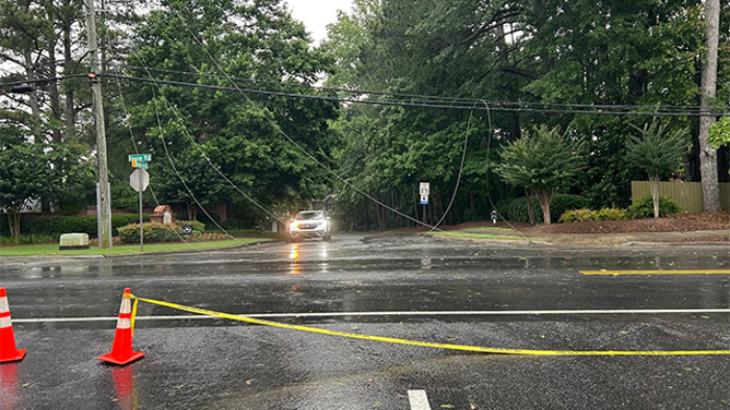
This image shows power lines that were brought down during severe weather in Roswell, Georgia, on Saturday, June 7, 2025.
(Roswell Police Department/Facebook) -

Apparent Tornado damage in McAlester, Oklahoma on June 7, 2025.
(Derrick James / @dljames0001 / X) -

Apparent Tornado damage in McAlester, Oklahoma on June 7, 2025.
(Derrick James / @dljames0001 / X) -

Apparent Tornado damage in McAlester, Oklahoma on June 7, 2025.
(Derrick James / @dljames0001 / X) -

Apparent Tornado damage in McAlester, Oklahoma on June 7, 2025.
(Derrick James / @dljames0001 / X) -

Apparent Tornado damage in McAlester, Oklahoma on June 7, 2025.
(Derrick James / @dljames0001 / X) -

Apparent Tornado damage in McAlester, Oklahoma on June 7, 2025.
(Derrick James / @dljames0001 / X) -

Apparent Tornado damage in McAlester, Oklahoma on June 7, 2025.
(Derrick James / @dljames0001 / X)
The central and eastern U.S. have been rocked by numerous severe weather reports over the last several days, including deadly storms in Mississippi and Georgia and possible tornadoes in Oklahoma and Virginia.
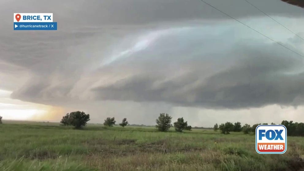
Deadly storms also tore across portions of Texas, producing 100-mph wind gusts and grapefruit-sized hail.
WATCH VS. WARNING: HERE ARE THE DIFFERENCES BETWEEN THESE WEATHER TERMS THAT COULD SAVE YOUR LIFE
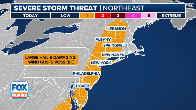
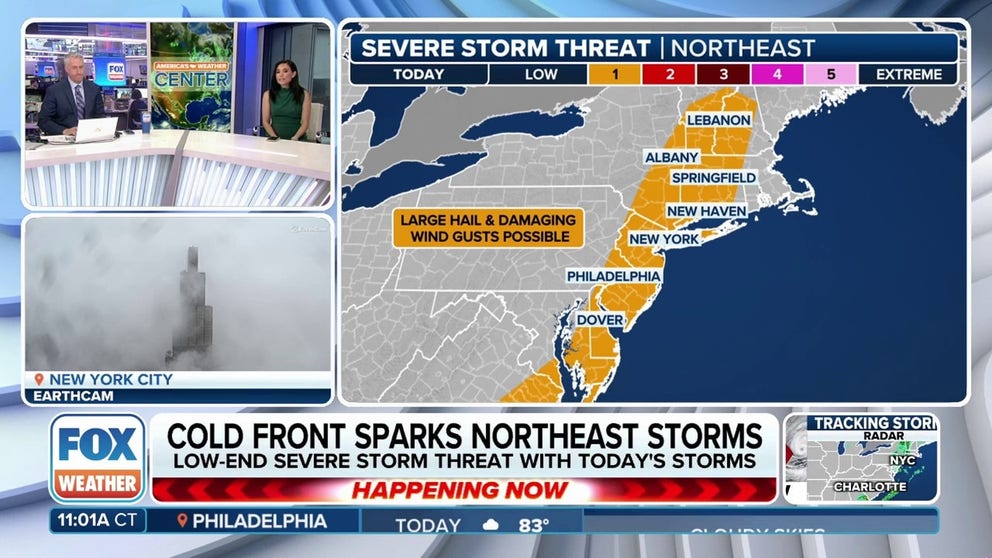
This animated graphic shows the severe weather threat along the East Coast on Tuesday, June 10, 2025.
The FOX Forecast Center said that as a cold front continues to march off to the east, thunderstorms will likely fire up along it as we get into the afternoon hours.
With daytime heating and plentiful moisture due to southerly winds ahead of the cold front, storms that develop may turn severe.
NOAA’s Storm Prediction Center (SPC) highlighted the East Coast from Georgia in the Southeast to portions of Vermont and New Hampshire in New England under a Level 1 threat on its 5-point severe thunderstorm risk scale.
HOW PUBLIC SAFETY OFFICIALS NOTIFY YOU DURING SEVERE WEATHER EMERGENCIES
The area is under a severe thunderstorm until the end of Sunday night and a flood watch until Monday morning.
This includes cities like Savannah in Georgia, Norfolk in Virginia, Philadelphia, New York City and Hartford in Connecticut.
However, it only takes one storm to turn lives upside down and have significant impacts. So, be sure to download the free FOX Weather app and enable notifications to be alerted to severe weather in your area.
The FOX Forecast Center said storms that develop on Tuesday could be capable of producing damaging wind gusts.
WHY DOES THE SKY SOMETIMES TURN GREEN DURING THUNDERSTORMS?

(FOX Weather)
Flash flooding is also a concern, with some Flash Flood Warnings already issued earlier Tuesday morning.
“Later (Tuesday), we may see flash flooding because the ground is pretty saturated, and some of these storms may produce an inch, 2 inches of rain, and it will be just enough,” FOX Weather Meteorologist Craig Herrera said.
Since the thunderstorms will be isolated, it could be difficult to pinpoint locations with the higher flood threat on Tuesday.
“It’s really tough to figure out the where, because these are isolated severe storms that will be developing this afternoon, and not everyone will see this type of weather,” FOX Weather Meteorologist Britta Merwin said.
“But, if we get an isolated severe storm in New York City or Boston, not only do we have an oversaturated environment, but we have an urban environment. And so we just need to watch out for that flood potential,” Merwin warned.
HOW HEAVY IS IT REALLY GOING TO RAIN?
Severe weather, flood threat ramps up in Plains
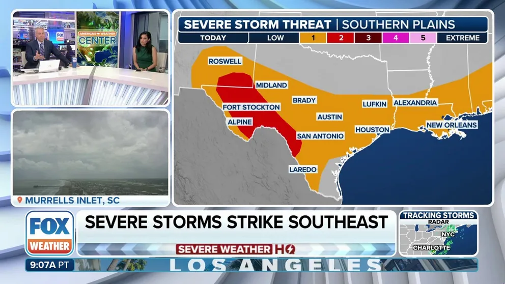
Forecasters are keeping their eyes on the potential for the development of severe weather across portions of the Plains, as well as along the Gulf Coast and into the Southeast. FOX Weather Meteorologists Bob Van Dillen and Marissa Torres have the latest on June 10, 2025.
Confidence is also increasing that severe weather and flooding could impact portions of the Desert Southwest, as well as the southern Plains.
A disturbance moving out of the Desert Southwest is approaching the region on Tuesday, and that will provide an added boost to thunderstorm development.
THESE ARE THE RAINIEST HOUR AND MINUTE IN AMERICAN HISTORY

(FOX Weather)
The SPC has placed portions of West Texas and southeastern New Mexico in a Level 2 out of 5 severe weather threat on Tuesday.
The FOX Forecast Center said that with winds remaining light throughout most levels of the atmosphere, storms will be slow-moving and could produce high rain totals and an increasing flood potential.
HOW MUCH LITERALLY IS A ‘BOATLOAD’ OF RAIN?

(FOX Weather)
NOAA’s Weather Prediction Center (WPC) has placed a large portion of the region in a Level 2 out of 4 flash flood threat on Wednesday and Thursday, with the threat shifting to the east into the Ark-La-Tex region by Thursday.
The FOX Forecast Center said that the San Antonio and Austin areas in Texas and points west into Fort Stockton and El Paso are under an exceptional drought, and flash flooding could be heightened due to water runoff from torrential rain rates.
The ground there is extremely dry, and water won’t have time to be absorbed fast enough, which is why there are concerns of flash flooding.

(FOX Weather)
#Millions #Plains #East #Coast #face #severe #weather #flooding #risk #Tuesday