
Video from Chesterfield, Missouri, Wednesday shows a tornado-warned storm moving through, blocking visibility.
Chances for strong to severe thunderstorms are expected to continue through the weekend and into next week as a series of frontal boundaries and associated moisture converge along the western edge of the Atlantic ridge.
Any thunderstorm that develops over the next few days has the potential to produce damaging winds, hail and even an isolated tornado as the country marches deeper into meteorological summer.
Depending on daily atmospheric conditions, some days will be more active than others, with severe weather reports ranging from a few dozen to several hundred.

(FOX Weather)
So far over the past week, Tuesday was the most active day for thunderstorms, with the Storm Prediction Center receiving over 200 reports of severe weather or damage stretching from the Plains to the Great Lakes.
On Thursday, the bulk of the activity is expected to focus on the Southern Plains, while Friday’s storms will likely center over the Mid-South.
Although more than three-fourths of the country is at risk for thunderstorms, the most concentrated activity will align with areas experiencing destabilizing mechanisms.

(FOX Weather)
Any thunderstorm that forms could turn deadly – capable of producing torrential rainfall and dangerous cloud-to-ground lightning.
By the weekend, precipitation will gradually shift farther south and east, where afternoon thunderstorms are common during summer.
ST. LOUIS GOES UNDER TORNADO WARNING JUST WEEKS AFTER DEADLY TORNADO
The FOX Forecast Center will be closely monitoring two critical weather situations: the potential for “training thunderstorms”, where multiple storms repeatedly pass over the same area, and the development of any squall lines or derechos that could sustain themselves over long distances.

(FOX Weather)
On Tuesday, thunderstorms dumped torrential rainfall over south-central Kansas, triggering Flash Flood Emergencies. A similar scenario could unfold again if a waterlogged community ends up under a slow-moving thunderstorm or a series of them.
Without a significant shift in the overall weather pattern, cities such as Oklahoma City, Nashville and Huntsville, Alabama could see anywhere from half a foot to more than a foot of rain over the coming weeks.
The forecast closely aligns with an outlook from NOAA’s Climate Prediction Center, which called for above-average precipitation through the first month of meteorological summer in areas that are receiving it.
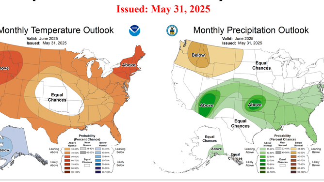
NOAA June climate outlook
FLASH FLOOD EMERGENCY STRIKES KANSAS WITH WATER RESCUES AROUND WICHITA
While the wet pattern is welcomed by some – especially for those who could easily face triple-digit heat and drought conditions – others may not be as fortunate.
The Upper Midwest is one region to watch closely, where precipitation may struggle and impact the status of agricultural products.
Known as the nation’s “breadbasket,” this region is in what is considered to be the growth stage for crops such as wheat, grains and corn.
Without sufficient rainfall over the coming weeks, concerns may grow for the health and the status of crops.
On the flip side, the Southeast coast will be a region to watch to see if any of these complexes of storms are able to make it as far south, such as Jacksonville or Charleston, S.C. – communities that do not need more rainfall in the short term due to recently experiencing a wave of tropical moisture.

(FOX Weather)
#Scattered #thunderstorms #rumble #eastern