A slow-moving area of low pressure will help deliver several inches of rainfall in the Sunshine State through the weekend and into next week.
Residents of the Sunshine State, who have been experiencing drought conditions and increased wildfire threats during the spring, may soon get a temporary reprieve, as an atmospheric river event promises to deliver the heaviest precipitation since winter.
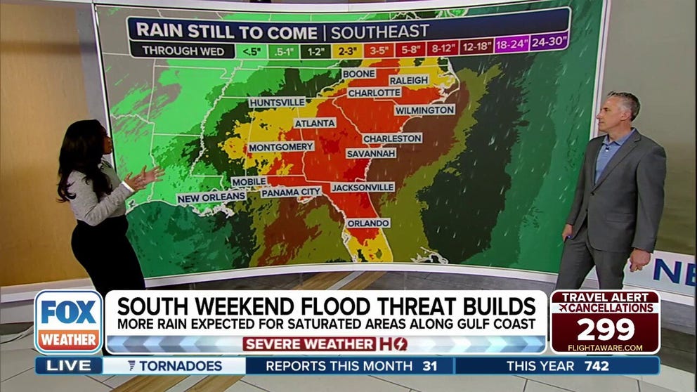
Forecast models show widespread rainfall, with totals ranging from around an inch in the least impacted areas to possibly upwards of a foot in communities that see repeated rounds of thunderstorms.
While atmospheric rivers are often associated with winter storms on the West Coast, the phenomenon can occur elsewhere in the U.S. and around the world wherever deep tropical moisture is involved.
Synoptic scenario map
(FOX Weather)
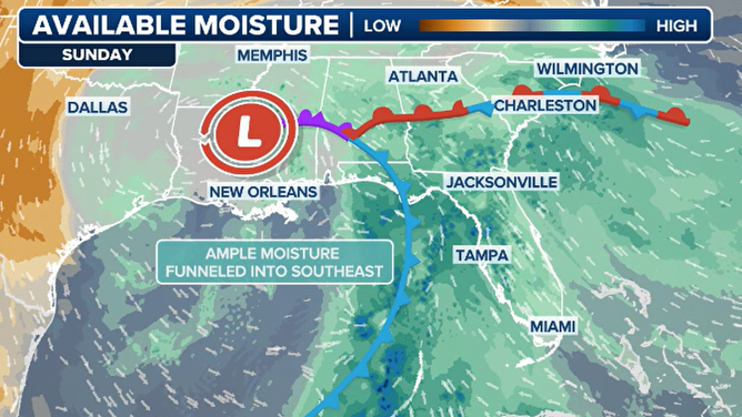
The FOX Forecast Center says the system responsible for this surge of precipitation is a low-pressure system that has become cut off from the main jet stream, making it slow-moving and capable of producing prolonged rain.
“When the low pressure is vertically stacked from the floor, all the way to the top of the troposphere, it doesn’t really move that fast because nothing’s pushing around. That’s what we have. And that’s that area of low is going to jack that coal front down and siphon a lot of moisture off the Gulf and the Caribbean too,” said FOX Weather meteorologist Bob Van Dillen.
Florida won’t be the only state impacted, as a broad swath of heavy precipitation is expected to stretch from Louisiana to the Carolinas, which will last into the first half of the upcoming workweek.
“It’s picking up in intensity, and it’s going to be even worse – later on – as we go through the day into Sunday and Monday,” Van Dillen stated.
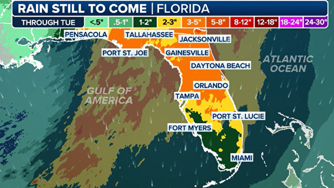
Florida forecast rainfall
NEW TO FLORIDA? HERE’S WHEN THE SUNSHINE STATE’S RAINY SEASON GETS UNDERWAY
But for the Sunshine State, the rain could help suppress wildfire activity during what is considered to be the peak of the fire season.
Most rainfall deficits in Florida currently range from 2 to 6 inches, with 96% of the state considered to be unusually dry and 25% experiencing severe drought conditions, according to the latest drought monitor.
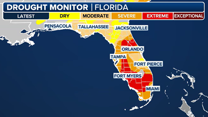
Florida drought monitor as of 5/9/2025
(FOX Weather)
The areas expected to receive the most rainfall are along the I-10 corridor, from Pensacola through Tallahassee and Jacksonville.
In contrast, the least amount of rain is expected well south of the I-4 corridor in South Florida.
Unfortunately, that’s where most of the fires have been, with Miami-Dade Fire Rescue recently responding to a large grass fire burning between Florida City and the Florida Keys.
WHERE YOU CAN DITCH THE RAIN AT UNIVERSAL’S EPIC UNIVERSE THEME PARK
So, while the persistent rain will be welcome news, the areas in the most desperate shape may see the least relief.
And of course, any thunderstorms that form have the potential to cause flash flooding and lightning, which can, in some cases, spark new fires.
Still, the developing atmospheric river is, overall, just what the doctor ordered and will serve as a reprieve until the state’s wet season kicks in during the next month or so.
#atmospheric #river #event #Floridas #fire #season